
While much of America and huge swaths of the planet have roasted in 2023, San Diego has not only escaped the worst of the heat, it has barely felt it.
This week, 50 Cent postponed a concert in Phoenix. The temperature was forecast to reach 116 degrees, and the rapper said that kind of heat would be “dangerous for everyone.” The high turned out to be 117 that day.
Phoenix, which reached 109 on Thursday, has hit 110 or hotter 52 times this year, one shy of the city’s calendar-year record, with all of September still ahead. Earlier in the summer, the city went 31 straight days at 110, melting the previous record of 18 days set in 1974.
A different kind of streak is going on in San Diego. August was the city’s 10th consecutive month that ended up cooler than normal. A stretch that long hasn’t happened in more than a half century.

On Sunday, New Orleans had its hottest day ever — 105 degrees. Many other locations in Louisiana also had their all-time highs. New Orleans set a daily high record on 20 of the first 28 days of August.
Houston reached 109 degrees on Sunday, also the highest reading ever in that city. Unprecedented heat stretched from coastal Texas to southern Alabama.
San Diego? It had its hottest day of 2023 on Tuesday, when the mercury shot all the way up to … 84. Not exactly all-time-high territory, or even a record for Aug. 29. That 84 was 27 degrees below the city’s any-day record of 111, set 60 years ago this month.
The long list of places with never-seen-before temperatures around the globe this year includes cities in China, France, Italy (Rome also hit 109) and Spain. National Oceanic and Atmospheric Administration scientists and other climatologists say 2023 will almost certainly go down as the hottest year ever recorded on the planet.
Meanwhile, San Diego has rarely broken a sweat. How has the heat that has scorched much of Earth dodged San Diego County?
Ivory Small, the science and operations officer at the National Weather Service’s Rancho Bernardo office, said atmospheric patterns over and near North America this year have varied little and have been conducive to local coolness.
“We’ve had strong high pressure pretty much covering most of the nation,” Small said. “At the same time, there’s been a weak trough (of low pressure) off the West Coast.”
(A version of that setup helped aim Tropical Storm Hilary at San Diego County on Aug. 20.)
In the summertime, high pressure makes air subside and heat up. The high over the Central U.S. has been a “monster,” Small said. It’s helped create those record-breaking temperatures in the South and Southwest. But the high’s reach has stopped short of the Southern California coast.
The low pressure off the West Coast has waxed and waned this summer, but it has frequently helped fend off the influence of that “monster” high. A West Coast trough usually sets up a flow that brings cooler air from over the ocean to the southwest of San Diego into the coastal strip. The hot inland air pushed west by the high doesn’t make it to the coast, or it is moderated by that southwest flow.

San Diego County’s inland valleys have also reaped the cooling benefits of the West Coast trough most of the summer. But early this week, the western edge of the high dominated in the valleys, and many spots topped 100 degrees.
The general trough pattern on the West Coast (another trough is present this weekend) goes back to early this year, Small said, and that helps explain not only the cooler-than-usual months, but also the state’s extremely wet winter and early spring. Troughs are associated with cooler, rising air and often with rain.
When a region gets locked into an atmospheric pattern for many months, temperature and precipitation records are more likely to fall. But what causes the atmosphere to lock?
Climatologists surmise that climate change is contributing to, if not causing, some of these locked-in patterns. Warming and the loss of ice in the Arctic has reduced the temperature contrast between northern and central latitudes. Climate scientists believe that the lost contrast is degrading the jet stream, the powerful, high-altitude winds that direct many storms around the globe.
The jet stream this year has been weaker and unusually fragmented, according to renowned climatologist Michael Mann at the University of Pennsylvania. A weaker jet stream is less able to dislodge entrenched areas of strong high or low pressure, which can allow extreme conditions to build.
Is more coolness on tap for San Diego? In the short term, yes. Labor Day Weekend should be a few degrees cooler than normal, and there are no apparent heat waves on the horizon. But the forecast from the Climate Prediction Center, which looks weeks and months ahead, shows the odds favor a warmer-than-normal fall.
The Numbers
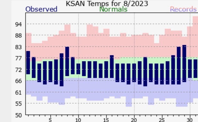
The average temperature in San Diego in August was 71.9 degrees, which is 0.5 of a degree cooler than normal. The last warmer-than-normal month in town was October. The average temperature for a day is determined by adding the high and the low, then dividing by two.
San Diego’s hottest day on record occurred on Sept. 26, 1963, when the mercury reached 111 degrees. But it was a dry heat. A Santa Ana dropped the relative humidity at San Diego International Airport to as low as 6 percent. I wrote story on the 50th anniversary of that day for the San Diego Union-Tribune.
The 1.84 inches of rain Tropical Storm Hilary brought to San Diego is the third most the city has recorded during the month of August. It rained 2.13 inches in 1977 thanks to remnants of Tropical Storm Doreen. In 1873, an unnamed storm dropped 1.95 inches. Monthly rainfall records in town go back to 1850. The 1.82 inches recorded on Aug. 20 this year is the most for any single summer day in San Diego’s history.
The article should state the City of San Diego, not San Diego county. East county has reached temperatures over 100 and most consistently has been in the mid ro upper 90’s all summer.
So the average temp is determined by adding the hottest and coldest day and dividing by two? That seems primitive. Wouldn’t a better measure be to add the temps of every single day of the month, then divide by that number of days?