
The pump is primed for another stretch of very stormy weather next week and into early February. What forecasters have yet to fully determine is where the next fire hose of moisture will be aimed: at San Diego again, at points to the north or even at the entire state of California.
Forecasters at the Climate Prediction Center in Maryland say something big is brewing in the Pacific. They say that most of California and much of the West have a greater than 70 percent chance of above-normal rainfall as January winds down and February begins.
“This (next) storm has the potential, based on our tools, to cause widespread impacts across much of the West,” said Ryan Bolt, a forecaster at the CPC. “But it is too early to know if this event will impact any specific area to the same extent as the event (in San Diego) on Monday.”
Southern California is expected to dry out for the next week or so. But early forecasts from the CPC show the risk of heavy rain increases for coastal regions of Northern California beginning Jan. 30, with the chances spreading southward along the coast the next day. Heavy snow is possible in the higher elevations of the Sierra Nevada.
Then comes a high risk (greater than 60 percent chance) of hazardous, heavy precipitation from Feb. 1 to 4 across California, Arizona and western New Mexico. This heavy precipitation, the forecasters say, “can lead to localized flooding and landslides, particularly in regions that have recently received heavy rains.”
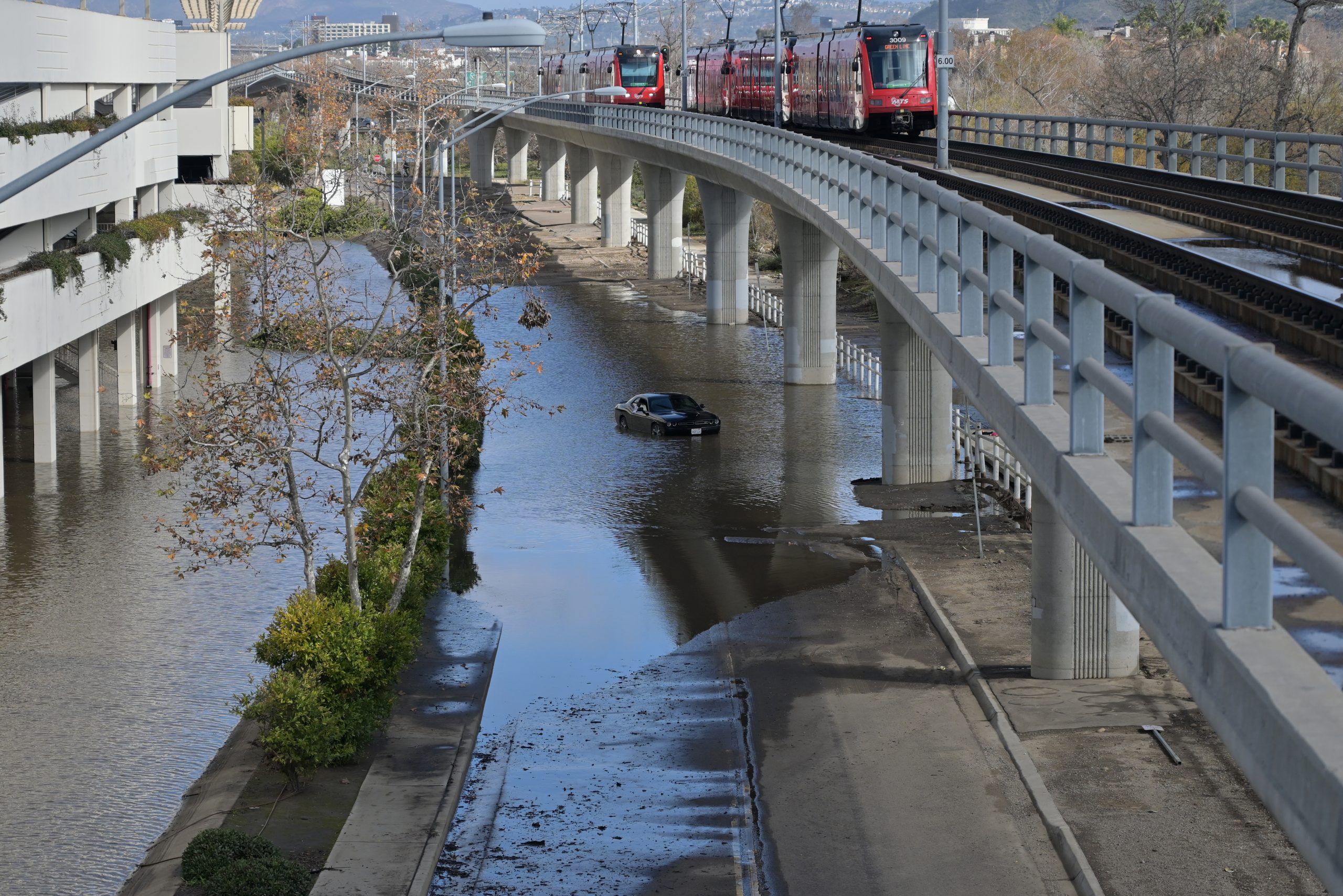
San Diego falls into that category. Monday was the city’s wettest January day ever, with records stretching back to 1850. It was the city’s fourth wettest day, any time of the year.
Alex Tardy, warning coordination meteorologist at the National Weather Service’s Rancho Bernardo office, described Monday’s storm, which pounded the entire county but especially the coast, as a “one-hundred-year event.”
Atmospheric River Rising

Bolt said the immediate trigger for the next storm is the development of a deep trough of low pressure off the West Coast that is expected to slowly progress eastward into the West. The trough should be fed by a strong connection to the subtropics, which is indicative of an “atmospheric river” that will bring enhanced rainfall.
A similar setup, although on a smaller scale, contributed to Monday’s deluge. Atmospheric rivers are long, relatively narrow regions of the atmosphere that transport most of the water vapor outside of the tropics. A small version can carry roughly the amount of water that flows out of the mouth of the Mississippi River; a big one can carry 15 times that amount.
A small such band of moisture fed Monday’s storm, which was further enhanced by abnormally warm waters off the San Diego County coast. Marty Ralph, research meteorologist and director of Scripps’ Center for Western Weather and Water Extremes, said that surface waters near the county coast were roughly 7 degrees warmer than normal on Monday.
“The atmospheric river was already going to produce substantial rain,” said Ralph at a Scripps seminar on Tuesday. “The warmer waters contributed substantially to making the rain heavier than it would have been.”
Scripps researchers have found that during El Niño years like this one, temperature increases off the county coast roughly mirror the temperature increases in the waters along the equator.
El Niños are marked by a multi-month, sea-surface temperature rise in the central Pacific. El Niños generally amplify and shift to the south the jet stream, the high-altitude winds that carry most storms across the globe from west to east.
But the presence of El Niño doesn’t guarantee storminess in Southern California. The last El Niño, in 2015-16, was bigger than the current one, yet most of California remained stuck in drought.
“The only thing I can safely say is that El Niño loads the dice in favor of wetter-than-average conditions across the southern tier of the U.S. over the course of a season (a 3-month average),” said Michelle L’Heureux, who heads the Climate Prediction Center’s team that monitors the El Niño and La Niña cycle. “With that said, El Niño (and a strong El Niño such as the current event) can make weather events like (Monday’s) more common over the course of a season.”
CPC forecaster Bolt said El Niño may be playing a role in helping to prime the atmosphere for the coming storm, but it is difficult to pin the entire storm on El Niño.
Tardy, the weather service meteorologist, said El Niño has been strong since summer. That’s helped beef up the jet stream, which is currently large and powerful.
“But that doesn’t guarantee we’ll be engaged with that jet stream in San Diego,” Tardy said. “You’ve got to be in the crosshairs. I don’t know if we will be. There’s a lot of energy and a lot of potential, but the key word is potential. Early February looks promising.”
The challenge for forecasters over the next few days will be concluding where that promise and potential will be fulfilled. Properly plotting the paths of the jet stream – and atmospheric rivers – will be essential.
Ralph, the research meteorologist at Scripps, said forecasters have had some success predicting the course of atmospheric rivers as much as 12 days out, but not consistently. He said researchers need to better understand how these plumes of moisture behave, irrespective of the presence of El Niño or its normally dry opposite, La Niña.
Somewhat paradoxically, atmospheric rivers have been common in a few La Niña years and rare in some El Niño years.
“There’s something going on that we haven’t quite figured out yet, to be honest,” Ralph said.
$2600 Day by day. Here comes the sublime opportunity for work from House. Various people these days dream around this sort of work opportunity. qk These people are able to succeed, essentially since they recognize the genuine blue work from household openings.
Here Go For Interface…….. https://WorkAboutHome6.blogspot.com
During the days preceding San Diego’s record rain disaster, extensive geoengineering was carried out across our skies. This catastrophic weather modification is much to blame. Every week, one can look up to see the thick white lines sprayed from contractors’ tanker planes which spread out forming strange cloud cover and thick haze, yet the official, most preposterous lie says these long stretches of sprayed toxic nano-particulates all are normal jet contrails. Nothing could be further from the truth. The scientific evidence is well documented and can be found at Geoengineering Watch dot org.