
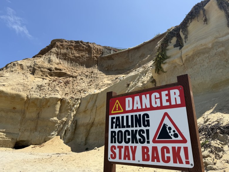
Below the cliffs overlooking Del Mar’s Dog Beach, caution tape encircles mounds of sand that have accumulated from repeated landslides. Signs warn beachgoers to, “stay back!”
A woman who owns part of this triangular peninsula, known as the North Bluff, has waited 25 years to develop it. The city of Del Mar has opposed every large-scale development effort there, though the land presents an opportunity to build the affordable housing the state mandates.
Del Mar needs to make way for 113 low-income units by 2029, according to the state of California. The city has failed to meet state targets, especially for low-income housing, in the past. It has also supported efforts to override state housing laws in favor of local control over housing and land-use decisions.
The city and property owner Carol Lazier are locked in a legal battle over her proposed 259-unit housing project, known as Seaside Ridge, that includes 85 affordable units. At the same time, Del Mar is scraping for available land and — facing pressure from the state — is eying the North Bluff for larger-scale development.
There’s just one problem: it’s eroding.
The rate at which the North Bluff is falling into the ocean depends on who you ask, but scientists know climate change is fueling sea level rise and creating more powerful waves that are accelerating erosion, also called retreat. The city’s own projections show that even under a best-case scenario, a driveway surrounding a mansion already on the bluff will be teetering off its edge by 2030. Worst case? Half the bluff would be in the ocean by 2100.
Despite the city’s own estimates on the bluff’s vulnerability to erosion, and its ongoing opposition to Seaside Ridge, it is looking into upzoning the North Bluff to allow for 20-units per acre.
“We’re out of vacant land,” said Del Mar City Councilmember Terry Gaasterland.
Right now, the entire 19.3-acre bluff is zoned for one-unit per acre. (To put that into perspective, Lazier is only allowed 7 units on the 6.9-acre parcel she owns under current zoning.)
The city has launched a search for an environmental consultant to see whether the sensitive bluff can accommodate additional housing.
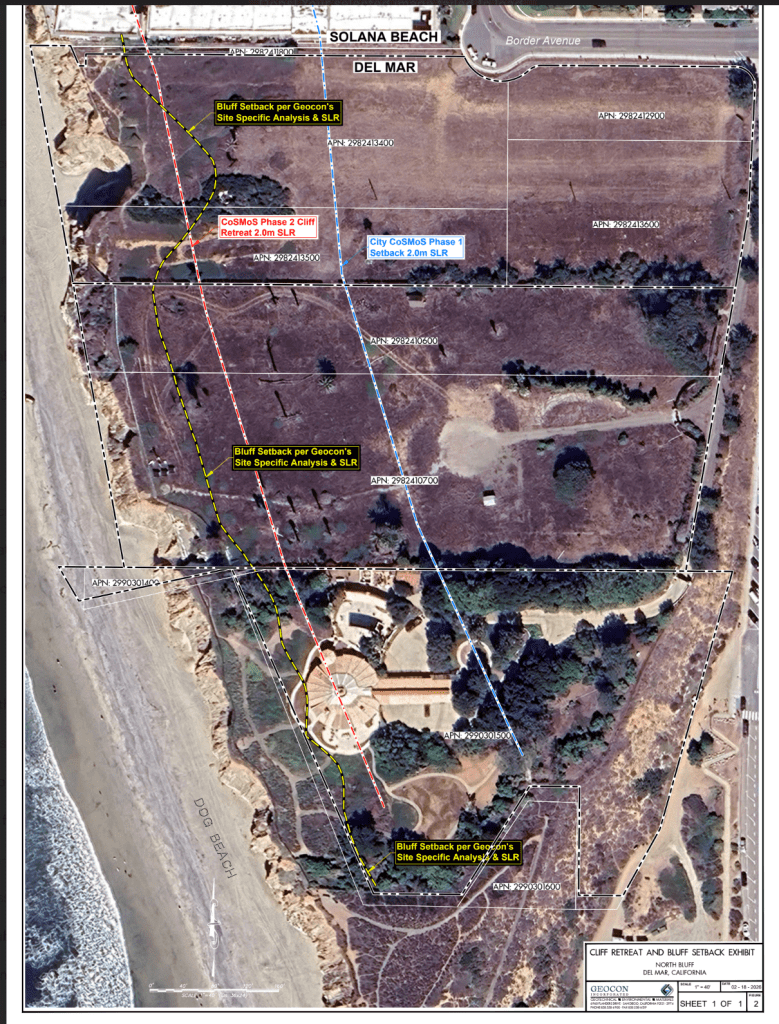
Meanwhile, Seaside Ridge offers the city a way to build most of the housing the state requires. Its own studies show the project is safe from bluff collapse, but only if the project sits at least 43 feet from the bluff’s edge – geologists described that as “ample” setback.
State agencies only require developers to prove buildings can withstand erosion for 75 years.
At a time when the state is dealing with a housing crisis, 75 years is not something to brush off.
“There may be better places to put the housing but ultimately housing must be built,” said Saad Asad, a representative of YIMBY Democrats, a housing advocacy group, adding that it’s concerning how long Del Mar has avoided meeting its housing goals.
On the other hand, Gary Griggs, a professor at the UC Santa Cruz who studies bluff erosion, believes we must be careful about how we plan for housing as sea levels eat at the coastline.
“How many of our housing demands are we going to be trying to meet on unstable coastal bluffs?” he said.
Helping Cities Plan for Risk
In a worst-case scenario, half of the northern bluff will be in the ocean by 2100 if humans don’t drastically reduce their use of fossil fuels, according to the U.S. Geological Survey or the USGS. This federal agency is the nation’s primary scientific resource on Earth’s systems.
The projections are a part of the agency’s 2015 Coastal Storm Modeling System project, which sought to map Southern California’s shoreline to help coastal cities plan accordingly for climate change.
The project’s estimates are based on different sea level rise scenarios guided by the state. These depend on how much greenhouse gas emissions humans produce in the future, whether that be significant transitions to clean energy or continuing at high and unchecked rates of fossil fuel use.
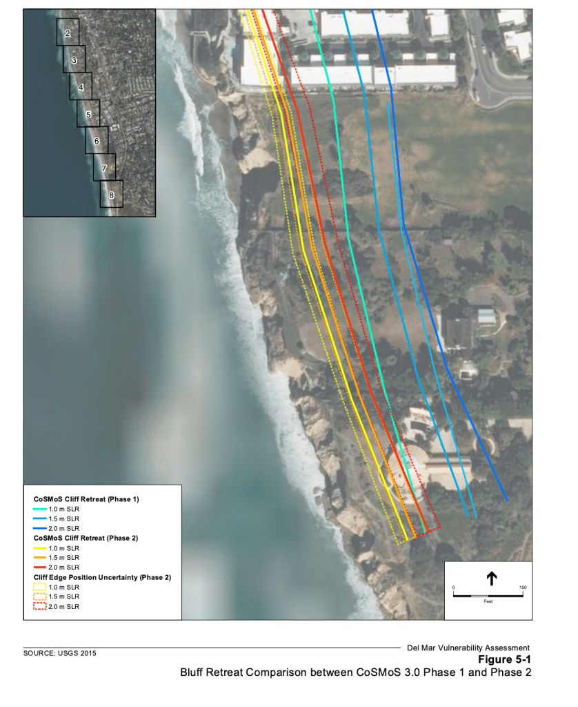
In this worst-case scenario for the North Bluff, sea level would rise by 6.6 feet from the level it is today.
“We expect to have more extreme wave conditions in the future and so all that just means that the base of these cliffs is going to get hammered more and more,” said Pat Barnard, a coastal geologist who helped work on the USGS models. “The result is that cliff retreat is going to accelerate.”
In 2018, the science behind climate change modeling got better and the USGS released an updated set of cliff retreat projections. Those indicated a less perilous future for the North Bluff.
Still, the moderate-risk projections, the case that Del Mar considers, show the cliff’s edge touching the border of its only developed property, a mansion closest to its southernmost tip, by 2100. Under the worst-case scenario, the cliff edge cuts halfway into the mansion by 2100.
Li Erikson, a research oceanographer at the USGS, said though the models have a high level of accuracy, they do have some limitations like a lack of data on what kinds of rocks the cliffs are made of which can impact how fast it erodes. Rather, the models serve as a first indicator of risk for cities to use as a guide for planning.
“That was the intent of the model was.., identifying hotspots,” she said. “When you see an area that is a hotspot… you should think twice and do a very local study before you invest, because this model projects that it’s a bad place to do it.”
What the City Says About the North Bluff
At its May meeting, the city of Del Mar rejected Seaside Ridge’s application for failing to submit additional materials it said it needed to process a zoning amendment with the California Coastal Commission — a state agency that enforces coastal environmental laws — an environmental impact report and other application entitlements. The developer didn’t submit those materials, arguing it doesn’t have to because state housing laws allow developers to fast track the application process for projects that include affordable housing.
At that same meeting, councilmembers discussed upzoning the North Bluff.
The city’s housing development plan, also called a Housing Element, identifies the North Bluff as a place the city could build to meet housing targets should other projects fall through. Even if the city can manage to scrape together enough housing, councilmembers said at the meeting they will have to rely on the North Bluff no matter what to reach future housing demands from the state.
In 2016, the city hired a consultant to map Del Mar’s areas of erosion risk so they could start planning for sea level rise.
Del Mar only considered the USGS’ first set of models in its planning after this consultant, Environmental Science Associates, told them the second models could “under-predict” erosion.
Environmental Science Associates took the USGS’ data to map where Del Mar’s coastline could be by 2030, 2050 and 2070 according to moderate and high sea level rise scenarios. The consultant also relied on local studies showing historic erosion rates.
A map produced by the city shows where it is believed the cliff might collapse in the future. By 2030, the map shows the cliff’s edge would brush the edge of a driveway encircling an existing mansion under the best-case sea level rise scenario the city considers – which is about 3 feet of sea level rise by 2100. By 2050, the cliff edge reaches the mansion’s front door. By 2100, half of the mansion is in the ocean.
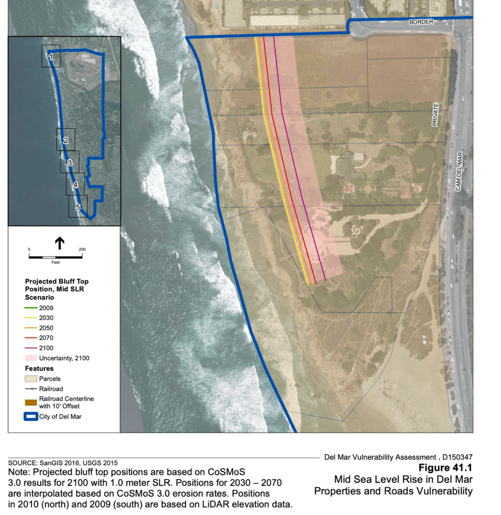
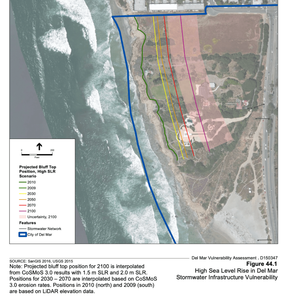
The city’s policies require properties start at least 40 feet from the edge of a cliff’s edge anyway, but its sea level rise predictions show the sea would consume at least that much cliff even if the world experienced a moderate amount of sea level rise.
Councilmember Gaasterland said the city is scraping for available land, which is why they are looking into upzoning the North Bluff, despite the city’s own estimates on its vulnerability to erosion.
“We’re using the best science available to us to understand the likelihood of what will happen and the increase in vulnerability due to sea level rise and coastal storms,” Gaasterland said of the cities current thinking on the models. She added the city will have to update their vulnerability assessment in accordance with a state senate bill by 2034.
The Developer’s Take
In 2023, Seaside Ridge released its own geotechnical studies of the North Bluff. They paint a much different picture than the city’s models.
After taking samples from the North Bluff, the developer’s consultant, Geocon Inc., estimated that the Seaside Ridge development project would be OK for the next 75 years under a high greenhouse gas emission and sea level rise scenario as long as it sat at least 43 feet from the cliff’s edge, and up to 73 feet in some areas. Their studies found that the bluff would retreat 33 feet with sea level rise in that time, far less than the hundreds of feet the USGS and the city’s models show.
Darren Pudgil, the development’s spokesperson, said Geocon Inc. used the current recommended way to determine how far a development should be placed away from a cliff’s edge, according to guidance by the Ocean Protection Council and the California Coastal Commission.
The actual setback of the project’s front set of buildings would vary between 60 and 97 feet after 17 feet was added to Geocon’s recommended setback for “conservatism” and to give the developer room to negotiate with the city over a 10-foot walking path they pledged they would add to ensure public access to coastal views.
“Seaside Ridge, as designed, adheres to the required development codes and coastal guidelines and will not pose a threat to those who will live there or the general public,” Pudgil said.
Seaside Ridge is moving forward with a lawsuit against the city under the Builder’s Remedy – a state law that allows projects to override local zoning if they submitted an application prior to a city having a certified Housing Element. Del Mar didn’t have one when Seaside Ridge first applied.
“Along with much-needed affordable housing, Seaside Ridge features a new public park and trail, which will provide public access to this amazing coastal resource for all income levels for the first time,” Pudgil added.
Predicting Bluff Collapse Is Full of Uncertainty
Griggs, the UC Santa Cruz professor who studies cliff erosion and sometimes advises developers on how to safely site projects from a bluff’s edge, said it’s hard to predict how sea cliffs will erode. They collapse in pieces and at different rates depending on the year. In a year like this, where a climatic swing called El Niño will fuel bigger waves, we could expect more erosion, he said.
To get a sense of how the North Bluff might collapse, he compared historical aerial photographs from 1979 and 2024, noting the land under a set of red buildings on the tip of the North Bluff has eroded in the 40-year period.
He praised Seaside Ridge for setting their project away from the cliff’s edge at all.
“Coastal erosion is an episodic process, so it usually happens during big winters with big waves and tides, and this has been a problem in the past because climate is irregular, and if you don’t look at enough years of records, you’re not going to get a good average measurement,” he said.
Adam Young, a researcher at the Scripps Institute of Oceanography, said erosion also depends on how people are trying to protect the bluffs. Adding sand to a beach, called sand nourishment, may protect the cliffs from encroaching waves for longer, Young said.
Though sand nourishment is extending the life of walkable beaches along North County, Griggs said it’s expensive and eventually comes with an expiration date.
“There’s absolutely nothing we can do to hold back the Pacific Ocean,” he said. “It’s going to keep advancing because of global warming and greenhouse gases and sea level rise. So, anything we do is going to be a Band-Aid, and the Band-Aids come (with) different price tags and different lifespans.”
The bluff’s stability is so contested, that one Solana Beach resident raised money to pay a consultant to review Seaside Ridge’s work to study the bluff. Carla-Echols Hayes opposed a previous project on the North Bluff and is also fighting development in other parts of Del Mar.
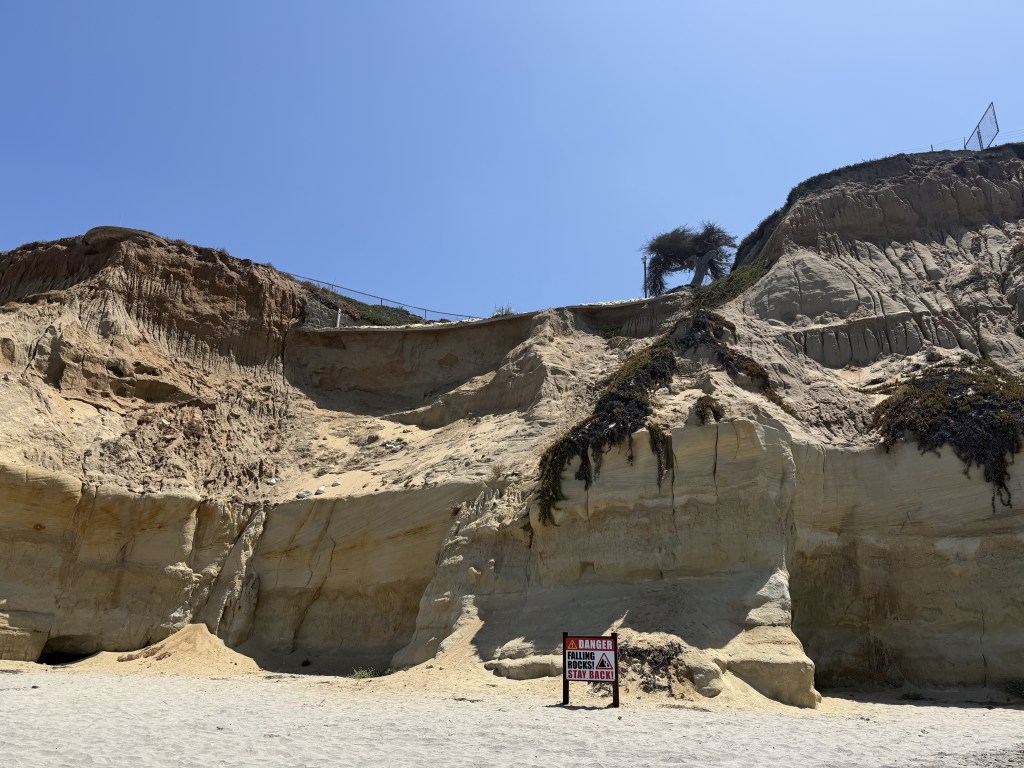
Dave Colbaugh, the geotechnical engineer she hired, said the studies of the North Bluff were thorough, but they didn’t consider the sea caves underneath, which can undercut the base of the cliff and cause destabilization. His report, which did not take any samples from the bluff, recommended that the project’s setback start behind the caves. At the time, Pudgil responded that the Coastal Commission’s guidance didn’t specify anything about sea caves.
“There were significant numerous fault lines running through this area, sea caves etcetera that were potentially detrimental to the stability of the bluff,” Colbaugh said.
Barnard, the coastal geologist, who is also a professor at UC Santa Cruz, said the battle over Seaside Ridge represents a tension that coastal cities will have to face more and more as housing needs expand and the available land to house people shrinks due to human-caused climate change.
“Cliffs erode, that’s what they do,” he said. “Ultimately, you’re going to have to deal with it sooner or later, but in this affordable housing crisis it’s a huge challenge.”
I understand the drive to develop the bluff, but that just sounds like a stop gap given that the bluff will erode. There have been discussions around using some land on the fair grounds. To me the dirt parking between the mini-golf course and the river make more sense. Yes the fair would lose parking, but there are already bus options during the fair and if parking is a problem for other events there could be similar solutions.
Using that parking lot makes a lot more sense than building on an already eroding bluff.
This is what happens when the state mandates a one-size-fits-all formula for additional housing without any consideration for the specific realities in different areas.
Meanwhile, has everyone forgotten about the Coastal Commission’s pressure for Del Mar to plan for “managed retreat”? There’s pressure to move homes out of the low lands due to encroachment by sea level rise but also pressure to build on unstable cliffs that will collapse with sea level rise. So, apparently Del Mar has to ignore the latter to comply with state laws. Utter idiocy.
I think Del Mar should stipulate to whoever builds on that bluff that the city is under no obligation to pay for any mitigation efforts to stabilize that bluff due to sea level rise and let the chips fall where they may.
There’s not enough water anyways with these growth mandates, and drinking our dung is the next fad.
“There’s not enough water”
in your fantastical world maybe, but here in SD there’s plenty.
I’m sorry but the Feds reduced our Colorado river draw.